History of Aerial Photography
Dark Room in a Hot-Air Balloon
The first known aerial photograph was taken in 1858 by French photographer and balloonist, Gaspar Felix Tournachon, known as "Nadar". In 1855 he had patented the idea of using aerial photographs in mapmaking and surveying, but it took him 3 years of experimenting before he successfully produced the very first aerial photograph. It was a view of the French village of Petit-Becetre taken from a tethered hot-air balloon, 80 meters above the ground. This was no mean feat, given the complexity of the early collodion photographic process, which required a complete darkroom to be carried in the basket of the balloon! Unfortunately, Nadar's earliest photographs no longer survive, and the oldest aerial photograph known to be still in existence is James Wallace Black's image of Boston from a hot-air balloon, taken in 1860. Following the development of the dry-plate process, it was no longer necessary carry so much equipment, and the first free flight balloon photo mission was carried out by Triboulet over Paris in 1879.
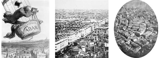
(left) Nadar "elevating photography to the condition of art", caricature by Honoré Daunier. Published in Le Boulevard 25th May, 1862.
(center) Nadar's earliest surviving aerial image, taken above Paris in 1866.
(right) Boston from a tethered balloon, 13th October, 1860, by James Wallace Black.
Kites, Pigeons and Rockets
Gradually, improvements in photographic technology made it easier to take cameras into the skies. Besides hot air balloons, early pioneers also used kites, pigeons and rockets to carry their cameras aloft.
The English meteorologist E. D. Archibald was among the first to take successful photographs from kites in 1882. He used a string of kites, with the camera being attached to the last. In France, Arthur Batut took an aerial photographs from a kite in 1889, in Labruguiere, France. He suspended his still rather large camera from a single kite, and set an automatically timed exposure. A slow burning fuse, responding to a rubber band driven device, triggered the shutter within a few moments of the kite being launched. Batut's first aerial photograph was taken in May 1888.
In California, the devastation of San Francisco after the 1906 earthquake and fire was captured by George R. Lawrence, using a camera attached to a string of kites high above the city. His specially designed large-format camera had a curved film plate to provide panoramic images, which remain some of the largest aerial exposures ever taken. The camera, which was large and extremely heavy, took as many as 17 kites to lift it 2,000 feet into the air. Lawrence also used ladders and high towers to capture lower level "aerial" photographs.
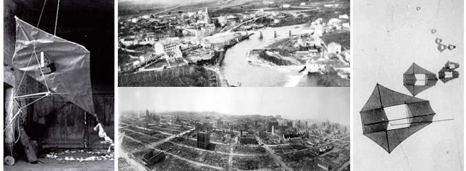
(left) Batut's kite, and (center top) his photograph of Labrugiere
(right) Lawrence's kites, and (center bottom) one of his panoramas of San Francisco after the earthquake and fire
The Bavarian Pigeon Corps used their pigeons to carry messages and for aerial reconnaisance. In 1903, Julius Neubranner designed a tiny breast-mounted camera for carrier pigeons. The camera could be set to take automatic exposures at 30-second intervals as the pigeon flew along. The flight path was not always reliable, however! Mostly used for military purposes, the birds were introduced at the 1909 Dresden International Photographic Exhibition, where postcards of aerial photographs taken above the exhibition were very popular with the public.
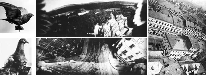
(left) Neubranner's pigeon mounted camera
(center and right) Aerial photographs taken on pigeon photo flights. Note the wingtips showing in the center top image of the castle.
The first successful aerial photograph from a rocket mounted camera was taken by the Swedish inventor, Alfred Nobel in 1897. He is best known nowadays for the Nobel prize. In 1906, Albert Maul in Germany, produced a more reliable method by using a rocket propelled by compressed air. His camera took an aerial photograph from a height of 2,600 feet, before being ejected and parachuted back to earth. He had patented the idea of using powder rockets in 1903, and by 1904 was testing gyroscopically-stabilised cameras launched by rockets and recovered by parachute. In 1912 he demonstrated his perfected rocket to the Austrian Army, but by then airplanes were found to be more effective.
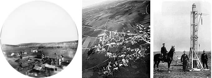
(left) Aerial photograph of the Swedish countryside, taken by Alfred Nobel from a rocket powered camera
(right) Albert Maul's rocket, and (center) one of Maul's aerial photographs of the German countryside.
Aerial Photography from Airplanes
The first aerial photography taken from an airplane was in 1909, by Wilbur Wright. He was in Italy, engaged in marketing planes to the Italian government, when he carried a passenger who took motion pictures of the military field at Centocelli, near Rome.
During World War I, aerial photography soon replaced sketching and drawing by the aerial observers. The battle maps used by both sides were produced from aerial photographs, and by the end of the war, both sides were recording the entire front at least twice a day. Cameras especially designed for use in airplanes were being produced, including thermal infra-red detectors. Stability and shutter speed remained a problem, and towards the end of the war Sherman M. Fairchild developed a camera with the shutter located inside the lens. This design significantly improved the quality of the images, and became the standard for aerial camera systems over the next 50 years.
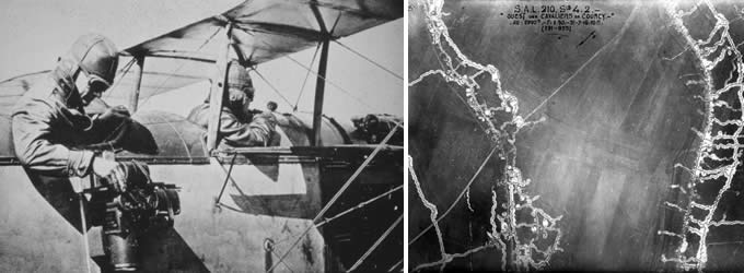
(left) Military aerial observer/photographer during World War I
(right) Vertical aerial photograph of trenches in 1916
The Business of Aerial Photography
Following the end of the war, the aerial camera was turned to non-military purposes. Sherman Fairchild took a series of overlapping photographs and made an aerial map of Manhattan Island. This aerial map became a commercial success and was used by several New York City agencies and businesses. Deals with other cities followed, as they found his aerial surveys to be faster and much less expensive than a ground survey. Aerial photography was shown to have civilian uses and could be a successful commercial venture.
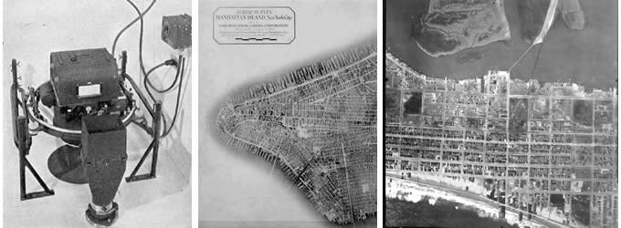
(left) Fairchild's camera became the standard for aerial photography
(center) Lower Manhattan Island, constructed from 100 aerial photographs taken by Fairchild Aerial Camera Corporation at an altitude of 10,000 feet on August 4, 1921
(right) Ocean City, New Jersey, part of an aerial survey of the New Jersey coast in 1920, believed to be by the Fairchild Aerial Camera Company.
Along with his successful aerial camera, Fairchild also designed and built airplanes with high-wings and enclosed cabins as a more protected and stable platform from which to take photographs. His innovation and strong commitment to the business of aerial photography brought more wide-spread use of aerial images. Before Fairchild died in 1971, he saw his cameras carried on Apollo 15,16, and 17, and while astronauts explored the lunar surface, his cameras mapped the moon.
New Technologies
Nowadays, aerial cameras tend to be digital, and most aerial photographers use gyro-stabilizers to counteract the movement of the aircraft. The resulting images are outstanding quality, high-resolution aerial views that can be delivered right to the client's desktop on the day of shooting. Aerial Photography is in wide-spread use for a diverse set of commercial, industrial, agricultural, governmental and private clients.
Copyright notice: The photographs on this page were published prior to 1923, and so are in the public domain. Attributions have been noted, where known.